Eastern Goldfields, Western Australia
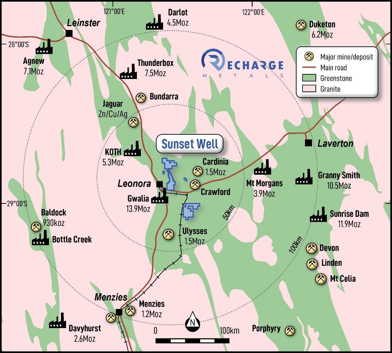
The Sunset Well Project is located approximately 10km east of Leonora and within 100km of seven operating gold processing plants. The tenement package comprises ten (10) granted Prospecting Licenses, fifteen (15) Prospecting License Applications, and four (4) Exploration License Applications, covering a total of 181km². Access is straightforward via the Goldfields Highway and Leonora-Laverton Road.
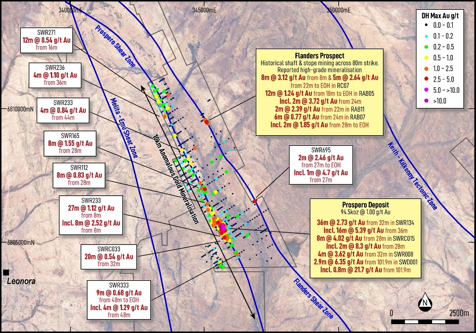
Gold mineralisation at the Sunset Well Project is interpreted to be associated with two major structures that traverse the tenement package. Historical drilling completed during the 1990s identified two primary gold trends, referred to as the Prospero Shear Zone and the Flanders Shear Zone, which are interpreted to reflect district-scale structural controls on gold mineralisation.
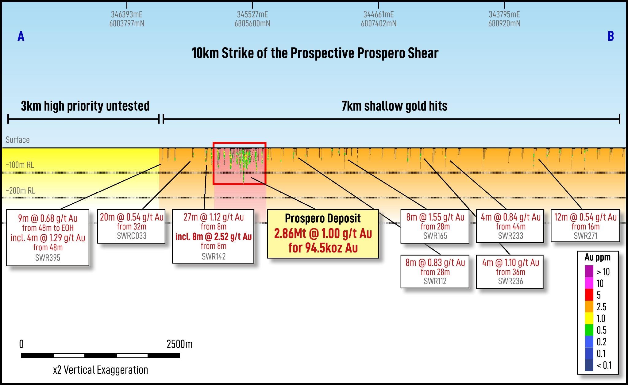
The 10km-long Prospero Shear Zone hosts a near-surface 94,500 ounce Inferred Gold Resource reported in accordance with the JORC Code (2012). The resource remains open at depth and along strike based on limited historical drilling, with only three drillholes extending below 100m vertical depth. Gold mineralisation has been identified along strike from the Prospero Deposit and the entire shear zone is considered prospective for further extensions and additional discoveries (refer Figures 2 and 3).
The Flanders Shear Zone is interpreted to be sub-parallel to the Prospero Shear Zone and has returned multiple historical gold intercepts from limited exploration, indicating significant potential for further investigation.
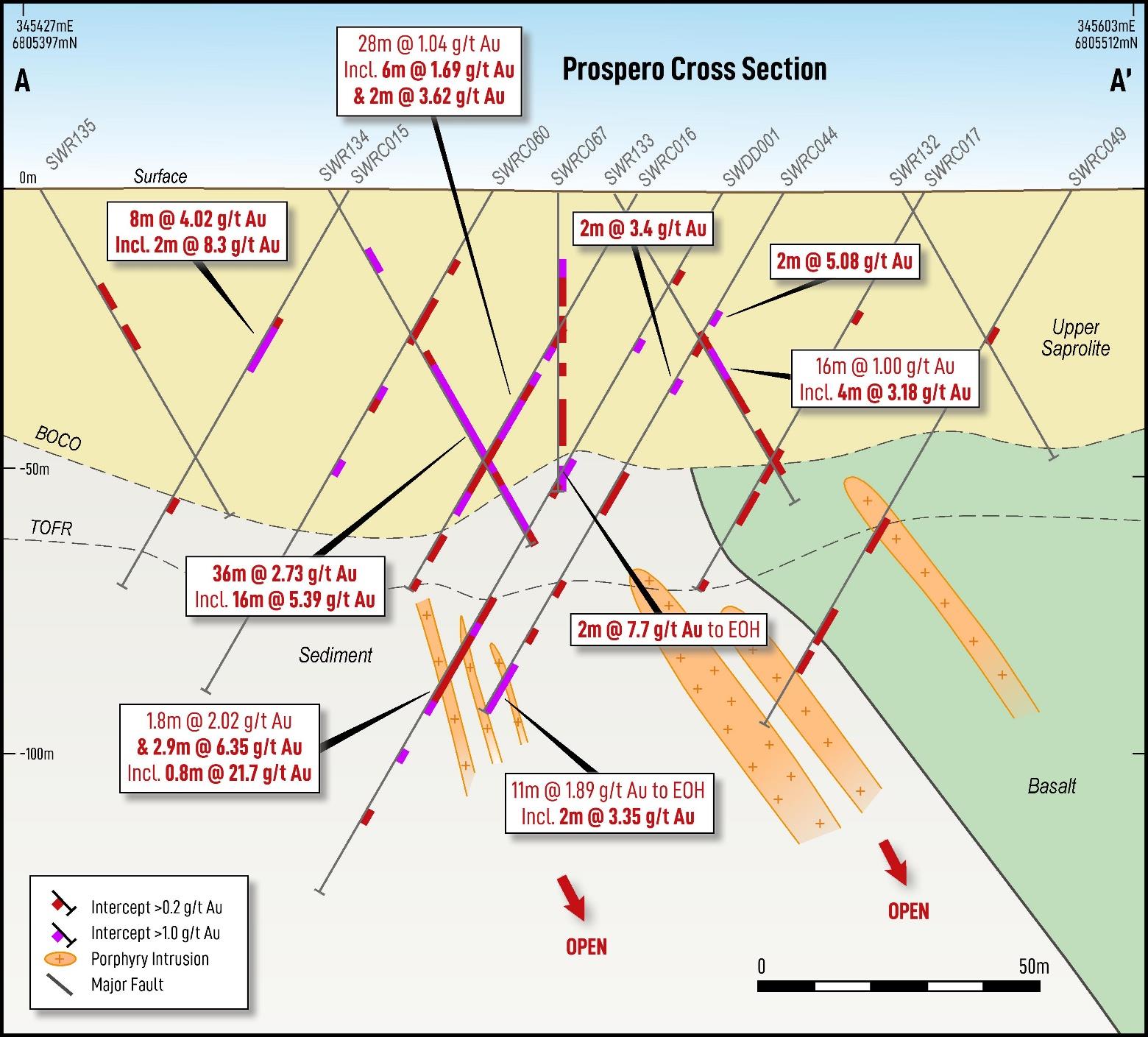
The Prospero Deposit comprises a near-surface gold system characterised by multiple northeast-dipping lodes over an interpreted strike length of approximately 1km. Historical drilling completed by Renison Goldfields Limited and Gilt-Edge Mining between 1993 and 1997 primarily tested shallow mineralisation, with limited drilling into fresh rock.
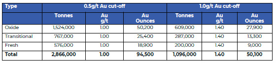
The Company reports that the Prospero Gold Mineral Resource Estimate (MRE) has been reviewed and is now reported in accordance with the JORC Code (2012 Edition). The Prospero MRE comprises an Inferred Mineral Resource of 2.87Mt at 1.0g/t Au for 94.5koz, using a 0.5g/t Au cut-off grade. limited drilling into fresh rock.
Based on historical drilling, the Prospero Deposit remains open at depth and along strike, with only three drillholes extending below 100m vertical depth (refer Figure 4).
A number of high-grade, near-surface gold intercepts were returned from historical drilling, indicating the potential for multiple mineralised lodes within the Prospero trend, including:
Refer Appendix 1 for a list of all significant intercepts in the 20 February 2026 ASX Announcement
No exploration drilling has occurred at the Prospero Deposit since 1997. Extensional targets have been identified from historical drilling and geological interpretation and will form a focus for near-term brownfields exploration.
The Company considers the Prospero trend to be prospective for extensions to the current resource and for additional discoveries through systematic modern drilling.
The Prospero Deposit lies within an interpreted 10km structural corridor associated with the Prospero Shear Zone (Figure 2 and Figure 3).
During the early 1990s, Renison Limited completed systematic shallow RAB drilling on approximately 200m × 50m spacing along this structure. Sampling from this drilling was undertaken as 4m composite samples, and limited follow-up RC drilling was completed at the time. Numerous anomalous gold intervals were returned along the trend from this wide-spaced, shallow drilling.
Significant historical intercepts along the Prospero trend, outside of the current Mineral Resource, include:
Refer Appendix 1 for a list of all significant intercepts in the 20 February 2026 ASX Announcement.
The average depth of historical RAB drilling along the Prospero trend is approximately 47m. Preliminary geological interpretation indicates that much of this drilling may not have penetrated below the base of weathering.
Recharge plans to undertake a comprehensive review of historical drilling and prioritise modern, systematic follow-up drilling of the highest priority targets along this trend.
The Flanders Shear Zone is located northeast of the Prospero Shear Zone and is interpreted to be a sub-parallel structure of regional significance (Figure 2).
The Flanders Prospect, within the Flanders Shear Zone, contains a series of historical shallow shafts, costeans and stopes developed over an approximate 80m strike length during mining activity in the late 1890s to early 1900s. Historical production records for the Flanders workings are incomplete; however, historical reports indicate that high-grade gold mineralisation was extracted from these workings.
Shallow RAB and RC drilling completed by Candiru NL in 1988 immediately adjacent to the Flanders historical workings intercepted a mineralised basaltic unit along the contact with a dolerite unit variably intruded by granodiorite porphyry bodies. Significant intercepts returned from the drilling at Flanders include (see Figure 2 and Table 4 for a full list of significant intercepts):
Gold mineralisation has been intersected to a vertical depth of approximately 55m and remains open at depth and along strike based on limited drilling. Minimal drilling has been completed along strike from the historical workings.
Drillhole SWRB105, completed by Gilt-Edged Mining in 1998 and located approximately 3.5km southeast of the Flanders Prospect, returned 2m @ 2.46g/t Au from 27m to end of hole, including 1m @ 4.7g/t Au from 27m (refer Figure 2).
Recharge plans to undertake field reconnaissance and systematic follow-up drilling to evaluate priority targets along the 8km length of the Flanders Shear Zone, as well as beneath and along strike from the historical workings.